NavIC or IRNSS
2021 APR 17
Preliminary >
Science and Technology > Space technology > Basics of space technology
What is NavIC?
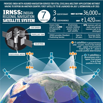
- NavIC (NAVigation with Indian Constellation) or the Indian Regional Navigation Satellite System (IRNSS) is an autonomous regional satellite navigation system, that provides accurate real-time positioning and timing services.
Features:
- It consists of three Geostationary Earth Orbit (GEO) satellites and four Geosynchronous orbit (GCO) satellites.
- Orbit altitude: 36,000 km
- It will provide two types of services:
- Standard Positioning Services (SPS), which will be provided to all users.
- Restricted Services – (RS), which will grant access only to authorised users (primarily military).
Accuracy:
- IRNSS will have the precision of 10-20 meters for civilian use. It is expected that Military will have more precision.
- GPS has 5 meters coverage for civilian use.
Range:
- It covers India and a region extending 1,500 km around it.
Need for IRNSS:
- During the Kargil war, US government denied vital GPS data for the region to India, necessitating the development of autonomous navigation system for strategic use.
Prelims Question
Consider the following statements regarding NavIC/ IRNSS:
1.It uses Geostationary and Geosynchronous satellites only.
2.It will be used exclusively for civilian uses.
Choose the correct statements from the codes given below:
(a)1 only
(b)2 only
(c)Both 1 and 2
(d)Neither 1 nor 2
Answer to the Prelims Question