Drones Regulation in India
2020 JAN 20
Mains >
Science and Technology > National institutions & initiatives > Innovation and New technologies
WHY IN NEWS?
On January 13, 2020, the Indian Aviation Ministry announced that registration of all drones in the country is mandatory.
WHAT IS UNMANNED AERIAL VEHICLE (UAV) OR DRONES?
- Unmanned aerial vehicle (UAV) is an aircraft that flies without a human pilot aboard. These are commonly known as Drone, and are controlled by a ground-based controller through a system of Communications between the UAV and the ground station.
- These can operate with different levels of autonomy either being remotely controlled by a human operator or autonomously by onboard computers.
CURRENT APPLICATIONS OF UAVS:
1. Defense Application:
- Unmanned Aerial Vehicles are the best guided weapons to carry out surveillance and reconnaissance (ISR) roles for the armed forces. UAV’s has high endurance, which allows a high success rate for search and strike missions.
|
Unmanned Aerial Vehicle Used by Indian Armed Forces
- Nishant is a multi-mission Unmanned Aerial Vehicle with Day/Night capability used for battlefield surveillance and reconnaissance, target tracking & localization, and artillery fire correction.
- UAV Panchi It is the wheeled version of unmanned aerial vehicle (UAV). Panchi UAV has autonomous flight capabilities and is controlled from a user-friendly Ground Control Station (GCS).
- Heron – It is a Medium Altitude Long Endurance (MALE) UAV, which is used by Indian Air Force. Developed by Israel, it has a flight time of 52 hours, but its actual time of flight depends on weight it carries and flight profile. It has some advanced features like artillery adjustment, surveillance and intelligence tasks.
- Rustom I tactical unmanned aerial vehicle with the endurance of 12 hours. The design of Rustom I will be based on National Aerospace Laboratories’ LCRA.
- Rustom H will be a larger unmanned aerial vehicle having a flight endurance of more than 24 hours. The design will be different from Rustom I and will have comparatively higher range and service ceiling
- Rustom II will be an unmanned combat aircraft based on the Rustom H model.It is the medium altitude long endurance UAV designed for carrying out surveillance and reconnaissance missions for the Indian armed forces.
It can carry different combinations of Pale words including electronic intelligence systems, synthetic aperture radar, and situation awareness systems etc.
It has an endurance of 24 hours and it is similar to the American Predator drones.
|
2. Non-Defense Applications
Apart from wide range of applications in Defence preparedness, Drones are a technology platform which has wide-ranging applications from photography to agriculture, from infrastructure asset maintenance to insurance. Drones range in size from very small and those that can carry multiple kilograms of payload.
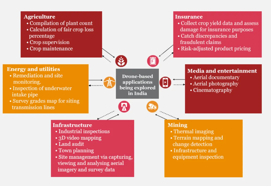
- Agriculture- Drones are able to provide live data from a range of sensors (including multispectral, NIR and lidar) and help in precision agriculture. In supporting precision farming, drones can do soil health scans, monitor crop health, assist in planning irrigation schedules, apply fertilizers, estimate yield data and provide valuable data for weather analysis
- It can be used for assessment of crop loss for insurance claims .
- Example: Deployment of drones allowed under PM FasalBima Yojana to study losses.
- Companies such as Skymet are using drones to provide agriculture survey services to insurance companies and the state governments of Maharashtra, Gujarat, Rajasthan and Madhya Pradesh
- Healthcare- Delivering quick access to drugs, blood, and medical technology in remote areas, transportation of harvested organs to recipients (through drones corridor), etc.
- Example: Companies like Zipline International have especially designed drones to deliver medical services in rural areas throughout in countries like Africa and other remote parts of the world.
- Disaster Management- Surveillance of disaster-affected areas to assess damage, locates victims, and delivers aid.
- Drones can scan affected areas with their thermographic cameras to locate missing persons.
- Urban Planning- Instant mapping and survey of the land which has to be developed avoiding congestion and increasing green cover.
- Example:Can help city planners to decide which areas may benefit most from green space, without causing further congestion.
- Recently, the Greater Chennai Municipal Corporation (GCMC) became first Municipal Corporation to map Chennai using drones.
- Conservation of Endangered Species:Drones fitted with high definition thermal cameras are used to track, inspect and monitor livestock remotely.
- Example: Gujarat Government has decided to deploy more than 50 drones. after successfully experimented the technology for the Wild Ass census.
- The government of Assam has partnered with Tata Consulting Services (TCS) to use drones to conduct surveillance, identify unauthorized settlements and to deter poachers in Kaziranga National Park.
- Weather Forecasting- Drones can physically follow weather patterns as they develop to understand the environment and imminent weather trends in a better way.
- Example: A company called Saildrone has developed autonomous sailboat drone that can collect oceanic and atmospheric data from the ocean surface which can be used aftermath to understand the environment and imminent weather trends.
- Waste Management- Identify where the garbage is so that it can be picked up the garbage picking vans. Drones can be used to clean ocean waste as well.
- Example: UAV like Roomba by RanMarine operates at the vanguard of these initiatives and have helped to clean oceans in the past.
- Mining- Drones in mining can be used in volumetric data capturing of ore, rock and minerals storage which is extremely difficult to measure manually.
- Inspections – Many systems such as power lines, wind turbines, and pipelines can be checked by drones.
- Surveillance – A drone allows recording and monitoring from the sky, and therefore, they are suitable to monitor public events, protests, or any suspicious happening without being heard and seen.
- Science & research– They help scientists a lot in research works to observe different occurrences in nature or a particular environment from the sky. For example, drones are used to document the archaeological excavations, in nuclear accidents (measuring contamination), in glacier surveillance, to observe a volcanic eruption, etc
- Ease of governance: Innovative use of Drones cost effectively monitors both the implementation and impact of various welfare schemes.
- A pilot project was taken up to identify and champion the use of drones for all MGNREGA projects of the Government. It can capture fine-scale spatial data such as the status of catchments, map the existence and condition of infrastructure, and help assess the impact of floods, droughts and erosion.
- Traffic Management: Potential uses for drones include everything from traffic management to inspections of traffic signals after installation or sampling vehicle speed along particular corridors.
- Internet Connectivity: Facebook experimented with a solar-powered drone called Aquila, which was envisioned as helping to provide internet access to rural parts of the world.
NEED FOR THE POLICY:
- The rise in the use of drones has safety and security implications. Interference in the air traffic can lead to collisions with other aircraft leading to accidents and injuries.Further, there are issues related to malicious use of these drones by loading them with dangerous payloads such as explosives, chemical, radiological for biological hazards. UAVs can and also create cyber security risks and vulnerabilities.
- Rise in illegal usage: The number of illegal drones in India is likely to be between 50,000 and 60,000, As per the study of FICCI committee on drones.
- Potential market: The industry value of unmanned aircraft systems (UAS) in India is projected to touch $885.7 million by 2021, while the global market size is expected to reach $21.47 billion.
- In the absence of a robust policy it has been difficult for these businesses to attract investors, limiting their ability to grow.
- The blanket ban which was imposed on 2014 did set back the emerging domestic drone industry by years, an opportunity well encashed by China. In the following years, the ban was shown clearly impractical as imported drones being easily available both online and offline platforms.
Issues related to use of drones:
- Surveillance by means of drones raises significant issues for privacy and civil liberties
- Drones being turned into potential weapons by criminals/ terrorists are another serious issue
- There are also ethical and legal issues related to drone warfare. ForExample: The shooting and killing of al-Qaeda leader Osama Bin Laden to the recent drone attack by the US on Iranian General Qasem Soleimani.
- Drones have been widely used for the cross border smuggling of weapons and drugs. Example: Recently, An Army soldier and two others have been arrested for allegedly smuggling drugs and weapons from across the Indo-Pak border using GPS-fitted drones.
- Biggest safety threat from drones is potential collisions with airplanes.Several instances of unidentified drone activity has been reported all over the country in recent years.There had been few episodes of unidentified flying objects disrupting operations at the Delhi airport.
- The increased drone activity also possess threat by invading the privacy of an individual.
FEATURES OF DRONE REGULATION 1.0 OR CIVIL AVIATION REQUIREMENT (CAR)
- To address these concerns the government has come up with a new set of norms to regulate the use of drones. The Directorate General of Civil Aviation (DGCA) is the designated authority in India to regulate the use of drones in the country and they have released a set of drone-regulations on 27th August 2018. These regulations are targeted to formalize the productive use of drones for civilian applications both for scientific research and infrastructure planning in India in rural and urban sectors. The new Policy called “Drone Regulations 1.0” or Civil Aviation Requirement (CAR) clarifies where, when and how drones can operate within India.
- As defined by DGCA, drones are remotely piloted aircraft (RPA). RPA is an unmanned aircraft piloted from a remote pilot station. The RPA, its associated remote pilot station(s), command and control links and any other components forms a Remotely Piloted Aircraft System (RPAS).
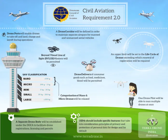
- Drone types - DGCA has identified multiple categories of drones, broadly classified as:
- Nano :Less than or equal to 250 gm
- Micro: From 250 grams to 2kg.
- Small: From 2 kg to 25kg.
- Medium: From 25kg to 150kg.
- Large: Greater than 150kg.
- Under the new policy, Nano drones which weighs less than 250 grams or equal does not need a registration or license. However, drones that belong to the remaining categories will need to be registered on the Digital Sky portal.
|
Digital Sky Platform
- The Digital Sky Platform is the national unmanned traffic management (UTM) platform that implements a 'no permission, no takeoff' system for remotely piloted aircraft.
- It is a novel system of software-based self-enforcement to minimize deviations from the CAR.
- The UTM platform operates as a traffic regulator in the drone airspace and coordinates closely with the defence and civilian air traffic controllers (ATCs) to ensure that drones remain on approved flight paths.
How to get permissions?
- To get permissions to fly, RPAS operators or remote pilots will have to file a flight plan in the Digital sky platform.
- Other than nano, all other categories of drones need to be registered with the government and issued with a Unique Identification Number (UIN).
- Beyond these permissions, an Unmanned Aircraft Operator Permit (UAOP) is also required for drone operators, except for nano-drones operating below 50 feet and micro-drones operating below 200 feet.
- The fee for a fresh UIN is Rs 1,000. The fee for a fresh UAOP is Rs 25,000 and is valid for 5 years. Payments for Unmanned Aerial Operator’s Permit (UAOP) and Unique Identification Numbers (UIN) will be accepted through the Bharat Kosh (bharatkosh.gov.in) portal.
- If a drone does not have permission to fly, it will not be allowed to take-off under the policy of No Permission-No-Takeoff (NPNT).
|
|
Air space has been divided into different zones.
- Red Zone: Flying not permitted
- Yellow Zone: Controlled airspace — permission required before flying
- Green Zone: Uncontrolled airspace — automatic permission ; requires only intimation of the time and location of the flights via the portal or the app.
- There are also specific regions around the country that have been marked as 'No Drone Zones'.
RESTRICTED ZONES FOR DRONES
- RPAs cannot be flown within 5km of the perimeters of the airports in Mumbai, Delhi, Chennai, Kolkata, Bengaluru and Hyderabad and within 3km from the perimeter of any other airport.
- It cannot fly within “permanent or temporary Prohibited, Restricted and Danger Areas” and within 25km from international border which includes the Line of Control (LoC), Line of Actual Control (LAC) and Actual Ground Position Line (AGPL).
- It cannot fly beyond 500 m into sea from the coast line and within 3 km from perimeter of military installations.
- It also cannot be operated from a mobile platform such as a moving vehicle, ship or aircraft.
- Eco-sensitive zones around National Parks and Wildlife Sanctuaries are off-limits without prior permission.
|
- Flying conditions - All drones, other than the Nano ones, must meet mandatory equipment requirements.
- These include GPS, anti-collision light, ID plate, radio-frequency identification (RFID) and SIM facilities.
- Training - All those requiring a UAOP must undertake a five-day training programme.This will expose them to regulations, basic principles of flight, and air traffic control procedures.
- DGCA has also designated a set of test sites for drone manufacturers and operators to innovate in a safe and secure environment.
- Drone Policy 2.0 - The ministry has constituted a task-force on the recommendation of Drone Policy 2.0.Drone 2.0 framework for RPAS are expected to include
- Certifications of sale and controlled operation of drone hardware and software
- Airspace management through automated operations linked into the overall airspace
- Beyond visual line of sight (BVLOS) flights
- Contribution to establishing global standards
POSSIBLE BENEFITS EXPECTED OUT OF NEW POLICY
- The drone market in india holds the potential for hitting over $1 trillion.The guideline would help to foster technology and innovation in the development of drones.
- This regulation will encourage a vast made in india drone industry.This policy will usher in a new idea of Drone Micro-Entrepreneurs
- The new drone policy has stirred excitement about the opportunities it could open up. But such policies must come armed with a precise safety and security framework and a robust institutional and logistical set-up to ensure they are not misused.
APPREHENSIONS ON THE NEW POLICY
- The new drone policy establishes an intricate system of application and approval procedures, it is lacking when it comes to thorough monitoring of drones.
- It also ignores the implications of free movement of smaller drones, which have been exempted from many of the regulatory procedures.
- The new policy, however, exempts certain categories of drones from such regulations. For example, nano drones flying below 15 metres in uncontrolled airspace for commercial, recreational, and research and development purposes are completely exempt. Their operators do not even need to obtain a Unique Identification Number.
- For micro drones operating below 60 metres, it is mandatory to inform the local police 24 hours before starting operations. But there is no centralised monitoring mechanism to ensure this procedure is followed.
- Such exemptions are likely to cause a mushrooming of drone operators which would made the regulation impractical.
- Nano drones flying around without much regulation may lead to the invasion of privacy. They may also be misused for unethical activities such as corporate espionage, trespassing, surveillance, unauthorized photography and burglary.
- It does not account for the rapid advances in artificial intelligence that could lead to unexpected applications of drones.
- The current regulations make it legal for non-governmental agencies, organizations and individuals to use UAVs.But the high costs put them beyond the reach of NGOs and rural communities.
- Critics are of the opinion that since the Centre has not allowed the use of drones for delivery of goods and food items, it will hinder its usage in the e-commerce and logistics industry.
|
International Practice
- In U.S., the Federal Aviation Agency (FAA) allows the civilian use of drones with caveats, while their commercial use is licensed.
- Various countries of the European Union (EU) currently have multiple regulations covering drone flights.
- No ICAO (International Civil Aviation Organisation) stands have been developed.
- In France, flights over urban areas are permitted only by licensed pilots and they can be operated at altitudes up to 150m. Public liability insurance is also required.
|
WAY FORWARD
- Drone operators have to ensure all mandated security measures are in place before each flight. They cannot transport any hazardous material and must have insurance for any damage to a third party. Violating the regulations could lead to their permits being suspended or cancelled.
- It must be provided with a centralised monitoring mechanism to check whether the operators are adhering to the norms.
- The government should ensure protection of privacy of citizens by limiting the use of drones for surveillance.
- There should be more comprehensive system for approving applications, renewing permits, alerting the agencies concerned to deal with emergencies, and recording the history of a vehicle can strengthen the policy’s applications.
- Aside from technical issues, the societal concern of making drone operation inclusive should be addressed.
- More representatives from outside the drone industry including civil society organisations and advocacy groups should be involved in framing the subsequent versions of regulations
- Regulation on use of drones in India should be effectively implemented to foster technology and innovation in the development of dronesand improve the ease of doing business, by sidelining unnecessary requirements and creating a single-window process.
Practice Question
Q. Drones have grown to become an important tool in the operations of various governmental organisations. In this context, drone regulation is perceived as an example of emerging technology governance. Discuss