NITI Aayog’s Project For Great Nicobar Island
2021 JUL 12
Mains >
Geography > Economic geography > Islands
WHY IN NEWS:
- Environment Appraisal Committee (EAC) of the Ministry of Environment, Forest and Climate Change (MoEFCC) has flagged serious concerns about NITI Aayog’s ambitious project for Great Nicobar Island
BACKGROUND
- The Island Development Agency (IDA) was constituted in 2017 under the aegis of the Ministry of Home Affairs.
- The IDA looks into the holistic development of islands.
- NITI Aayog has been mandated with the task to steer the holistic development of the islands sustainably.
- The program aims to attain sustainable development in the identified Islands without damaging the pristine biodiversity.
- In this regard, the NITI Aayog came up with
- Great Nicobar Development plan
- Sustainable Development of Little Andaman Island
ABOUT THE GREAT NICOBAR DEVELOPMENT PLAN
- The NITI Aayog has developed Rs 75,000 crore vision for the ‘Holistic Development of Great Nicobar Island in Andaman and Nicobar Islands’.
- The plan envisages the use of about 244 sq. km. region for development purposes.
- The plan entails the development of a transshipment terminal with a Greenfield international airport, townships and solar and gas-based power plants.
- Andaman and Nicobar Islands Integrated Development Corporation (ANIIDCO) will be the nodal agency for the implementation of the Great Nicobar Development plan.
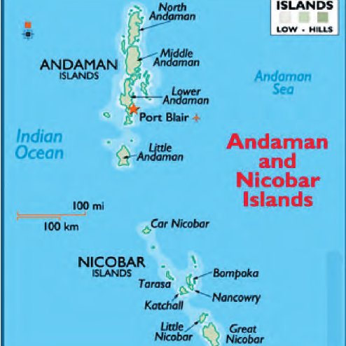
ABOUT GREAT NICOBAR
- Great Nicobar is the southernmost and largest of the Nicobar Islands of India, north of Sumatra.
- Great Nicobar Island was severely affected by the 2004 Indian Ocean earthquake tsunami with many deaths, and was cut off from all outside contact for more than a day.
- The island covers 921 km2 but is sparsely inhabited, with a population of 8067, largely being covered by rainforest and known for its diverse wildlife.
- The island is home to:
- Great Nicobar Biosphere Reserve
- The majority of the island is designated as the Great Nicobar Biosphere Reserve
- It is home to many endemic species of plants and animals including the Nicobar scrubfowl, Nicobar long-tailed macaque, saltwater crocodile (Crocodylus porosus), giant leatherback sea turtle (Dermochelys coriacea), Malayan box turtle, Nicobar tree shrew, reticulated python (Python reticulatus) and the giant robber crab
- Indira Point
- It is the southernmost point of India
- INS Baaz naval air station
- It is near Campbell Bay under the joint-services Andaman and Nicobar Command (ANC) of the Indian Armed Forces.
- The island has several rivers, including the Alexandra, Amrit Kaur, Dogmar and Galathea
SIGNIFICANCE OF THE GREAT NICOBAR DEVELOPMENT PLAN
- Job opportunities for locals:
- The plan involves the creation of infrastructure (ports, airports, etc.) >> this will help in creating satisfactory jobs for the locals.
- Economic development:
- It will help in creating tourism prospects in the region >> This will aid the income generation in the region.
- The per capita income in Andaman & Nicobar Islands for the year 2015-16 was Rs. 1,24,361.
- This was much lower than the per-capita income of other Union Territories
- Improving basic amenities for island residents:
- Island residents find the power outages a major problem, especially during the monsoons, as well as a paucity of groceries and rice, sugar, salt, diesel and petrol, thanks to irregular ship services.
- Few vegetables are grown commercially on Great Nicobar, so the island isn’t yet self-sufficient
- Developmental plans will improve the amenities available to residents
- Connectivity:
- The development of world-class infrastructure will help in improving inter-island connectivity >> thereby, improving governance and boosting export potential.
- Social Benefits:
- It would further create affordable state-of-the-art facilities for healthcare, quality education, and adequate air, sea and web infrastructure.
- It will facilitate the delivery of e-governance services such as telemedicine and tele-education, as a part of the Digital India initiative.
- Strategic benefit:
- The Nicobar Island located in proximity to the strait of Malacca.
- This demands the creation of robust infrastructure for meeting geopolitical interests in the region.
- The islands are also home to India’s only tri-services command – the Andaman and Nicobar Command (ANC).
- The command holds immense relevance due to rising Chinese aggression in the Indo-Pacific region.
CONCERNS
- Threat to biodiversity:
- Construction in the region threaten the biodiversity of the region
- The beaches at the mouth of the river Galathea in South Bay are among the most prominent nesting sites of Giant leatherback turtles.
- Similarly, 90% of the Nicobar megapode’s nesting sites are within a distance of 30 m from the shore.
- Against the spirit of environmental legislations:
- Standing Committee of the National Board for Wildlife (NBWL) denotified the entire Galathea Bay Wildlife Sanctuary for building port and other related infrastructure.
- Wildlife Protection Act 1972 – the parent legislation from which NBWL draws its powers – doesn’t permit the diversion of protected areas, like national parks and sanctuaries, unless the diversion will benefit the area’s wildlife.
- Hence the plan violates the purpose of such legislations
- Not considering the water resource availability
- The project is also unrealistic given the islands’ prevailing water scarcity.
- The islands depend on rain for their freshwater needs. The longest river flowing through Great Nicobar, Galathea, isn’t voluminous enough.
- There may not be enough freshwater to sustain a large-scale developmental project over the long run
- Affects tribal rights:
- The island has two indigenous groups – the Nicobarese and the Shompen, a forest-dwelling community.
- The proposed project areas are important grounds for Shompen.
- Initiation of work would make large forest areas inaccessible and useless for the Shompen.
- Limited consideration to disaster vulnerability:
- The island is prone to natural disasters and more so in the light of aggravating climate change.
- This reality does not receive due consideration in the development strategies.
- For example, Andaman and Nicobar Islands are located in a seismically highly active zone (zone V).
- The NITI Aayog’s strategy of island development does not auger well with this vulnerability
- Further, Andaman and Nicobar observe frequent storms and cyclones. This can easily destroy constructed structures.
- For instance, In 2004 Tsunami caused a 3-4 metre land subsidence. This is the reason for the submergence of a lighthouse located at Indira point.
- Undermining international obligations:
- The Galathea Bay Wildlife Sanctuary forms part of a UNESCO World Heritage Site.
- So preservation of this pristine biodiversity is an International Obligation of India.
- Lack of inclusiveness in development:
- The inhabitants of the island have their own priorities, lifestyle and needs.
- In accordance with that, they have developed traditional wisdom with regard to existence on these islands
- Current development plans discount these traditional wisdoms
WAY FORWARD
- Due consideration to tribal rights:
- The development work must be carried out with due regard to tribal rights. This would involve proper adherence to policies like the Shompen Policy of 2015.
- The Shompen Policy of 2015 calls for giving priority to tribal rights over large scale development proposals.
- Engaging with foreign countries with past experience in island development:
- India should enhance cooperation with countries like Japan, South Korea etc. This will help in developing successful island development models
- Eco-friendly construction:
- Construction of infrastructure should be done using eco-friendly practices like strict adherence to GRIHA code for building construction.
- GRIHA means Green Rating for Integrated Habitat Assessment.
- Follow NITI Aayog’s Panchatantra Principles of Sustainable Development:
- A mix of P2 (Public Projects), P3 (Public Private Partnership) and P4 (People Public Private Partnership) projects
- Optimum Budget allocation
- Creation of an environment conducive for private sector participation
- Peoples’ participation in equity
- Development Strategy = Social Strategy + Supportive Strategy
- Social Strategy >> means strategies to generate additional income for the islanders
- Supportive Strategy >> means strategies to create assets for sustaining their high level of income in the long run
- Conduct proper Environment impact assessment
- Any construction under the Great Nicobar Development plan should involve a proper Environment impact assessment (as mandated by the Environment Protection Act 1986).
- This will make development more feasible and it will minimise the threat of excessive environmental degradation.
PRACTICE QUESTION:
Q. “Island development strategy in India should give due consideration to local priorities along with infrastructural and strategic needs”. Comment