Geospatial Sector In India
2022 MAR 9
Mains >
Science and Technology > Miscellaneous > Innovation and New technologies
WHY IN NEWS?
- The Ministry of Science and Technology recently released new guidelines for the Geo-spatial sector in India, which deregulates existing protocol and liberalises the sector to a more competitive field.
WHAT IS GEO-SPATIAL DATA?
|
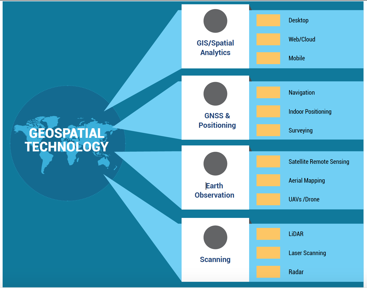
Geospatial Technology is a term used to describe a range of modern tools like the Geographic Information System (GIS), Remote Sensing (RS) and Global Positioning System (GPS).
Geospatial technology enables us to acquire data that is referenced to the earth and use the data for analysis, modeling, simulations and visualization.
|
- Geospatial data is data about objects, events, or phenomena that have a location on the surface of the earth.
- The location may be static in the short-term, like the location of a road, an earthquake event, malnutrition among children, or dynamic like a moving vehicle or pedestrian, the spread of an infectious disease.
- Geospatial data combines location information, attribute information (the characteristics of the object, event, or phenomena concerned), and often also temporal information or the time at which the location and attributes exist.
- Geo-spatial data usually involves information of public interest such as roads, localities, rail lines, water bodies, and public amenities.
- The past decade has seen an increase in the use of geo-spatial data in daily life with various apps such as food delivery apps like Swiggy or Zomato, e-commerce like Amazon or even weather apps.
STATISTICS:
- According to India Geospatial Artha Report 2021
- Indian geospatial economy is currently valued at Rs 38,972 crore and employs approximately 4.7 lakh people.
- Geospatial market is projected to reach around 1 lakh-crore by the year 2029 with 13% Compound Annual Growth Rate (CAGR).
SIGNIFICANCE OF GEOSPATIAL SECTOR:
- National Security:
- The Government of India started investing heavily in geospatial technologies after the Kargil war.
- The war highlighted the adverse effects of dependence on geospatial data sourced from foreign countries.
- Implementation of Schemes:
- The flagship schemes of the Government like the Gati Shakti program can be smoothly implemented using geospatial technology.
- Employment Generation:
- Private Companies like Amazon, Zomato etc. use this technology to smoothly conduct their delivery operations which supports livelihood generation.
- Further the estimated human resource size of the sector is expected to reach 9.5 lakh by 2025.
- Boost to Make in India:
- Focusing on the sector will allow Indian companies to develop indigenous apps like an Indian version of google maps.
- Land Record Management:
- Using this technology, the data related large number of landholdings can be appropriately tagged and digitized. It will not only help in better targeting but would also reduce the quantum of land disputes in courts. Barring Karnataka, the records are not updated in other states.
- Crisis Management:
- Technology and logistics were perfectly supported through the use of geospatial technology during the Covid 19 vaccination drive.
ISSUES WITH PRESENT POLICY ON GEO-SPATIAL DATA:
- Heavy regulation:
- There are strict restrictions on the collection, storage, use, sale, dissemination of geo-spatial data and mapping under the current regime. The policy had not been renewed in decades and has been driven by internal as well as external security concerns.
- Dominated by government:
- The sector so far is dominated by the Indian government as well as government-run agencies such as the Survey of India and private companies need to navigate a system of permissions from different departments of the government (depending on the kind of data to be created) as well as the defence and Home Ministries, to be able to collect, create or disseminate geo-spatial data.
- Absence of a sizeable geospatial market:
- There is low demand for geospatial services and products on a scale linked to India’s potential and size.
- This is mainly due to the lack of awareness among potential users in government and private sector.
- Human Resource Deficit:
- Though India has many who are trained in geospatial this is mostly either through a master’s level programme or on-job training.
- Unlike the West, India lacks a strata of core professionals who understand geospatial end-to-end.
- Not much of a percolation:
- India has a robust ecosystem in geospatial, with the Survey of India, ISRO, remote sensing application centres (RSAC)s, and the National Informatics Centre (NIC) in particular, and all ministries and departments, in general, using geospatial technology.
- However, the full benefits have yet to percolate to the public; neither is there much contribution to the nation’s GDP.
- Used solely for defence purposes:
- Initially conceptualised as a matter solely concerned with security, geo-spatial data collection was the prerogative of the defence forces and the government.
- GIS mapping was also rudimentary, with the government investing heavily in it after the Kargil war highlighted the dependence on foreign data and the need for indigenous sources of data.
- Poor data sharing framework:
- The lack of clarity on data sharing and collaboration prevents co-creation and asset maximisation.
- The unavailability of foundation data, especially at high-resolution, is also a constraint.
STEPS TAKEN:
- Guidelines for Geospatial Data, 2021:
- In 2021, the Department of Science and Technology (DST) released guidelines for acquiring and producing Geospatial Data and Geospatial Data services including maps (Guidelines).
- These Guidelines were issued with the aim of liberalising the regulations in relation to the collection, acquisition and use of Geospatial Data.
- Previously, there existed a licensing regime administered by the Survey of India (SoI) for the use of their maps.
- However, these have become somewhat obsolete and redundant with the advent of publicly available geospatial services, which have made Geospatial Data freely and commonly available.
- Key reforms introduced by the Guidelines are:
- Self-Certification Regime:
- Previously, the creation, publishing and use of Geospatial Data, including conducting of mapping activities, was strictly regulated and subject to a complex approval process.
- The Guidelines have now removed all requirements for prior approval or license.
- The Guidelines have provided a wide permissibility to individuals, companies, organizations, and public bodies to acquire Geospatial Data, and provide value added services in relation to such data, including building applications
- Restricted Data
- While the erstwhile regime prevented mapping in certain areas by classifying them as 'restricted areas' where mapping activities were prohibited or strictly governed
- New Guidelines instead provide for a specific list of sensitive attributes which cannot be shown on any map.
- Focus on Indian Entities
- Subject to the regulations on Sensitive Attributes, the Guidelines allow Indian entities to
- Acquire, collect, generate, prepare, disseminate, store, share, publish, distribute, update, digitize and/or create Geospatial Data, including maps, of a spatial accuracy above the specified threshold, provided that such data is stored and processed only in India
- Use technologies such as ground truthing and verification, and access Indian ground stations and augmentation services for real time positioning
- Conduct activities such as terrestrial mobile mapping survey, street view surveying, and surveying in Indian territorial waters, regardless of the Threshold.
- While non-Indian companies are not permitted to undertake any of the above, they can license Geospatial Data and maps which may be above the Threshold for the purposes of serving their Indian customers.
- Export and localisation of maps
- The export of maps and map data finer than a 1:250,000 resolution was previously restricted by the government.
- The Guidelines have liberalised this and have permitted exports of maps with resolutions up to the Threshold (1:100).
- Digital maps and Geospatial Data with accuracy finer than the Threshold however must be localised, and are only permitted to be stored and processed on servers located within India.
- Inter-ministerial Committee
- The Guidelines introduce the constitution of a Geospatial Data Promotion and Development Committee
- The Committee shall have representatives from all relevant government departments.
- The Committee will be responsible for governing and promoting all activities in relation to Geospatial Data and is also tasked with deciding on disputes which may arise from the identification of Sensitive Attributes, and the associated regulations.
- Geospatial Energy Map of India
- It is developed by the NITI Aayog in collaboration with Indian Space Research Organisation (ISRO) with the support of Energy Ministries.
- It provides a holistic picture of all energy resources of the country.
- It enables visualisation of energy installations such as conventional power plants, oil and gas wells, petroleum refineries, coal fields and coal blocks, district-wise data on renewable energy power plants and renewable energy resource potential through 27 thematic layers.
- Union Budget 2022-23:
- Government would support the use of Kisan drones for land assessment, digitization of land records and spraying insecticides and nutrients.
- Yuktdhara Portal:
- The Ministry of Rural Development has launched a new geospatial planning portal named ‘Yuktdhara’.
- It will serve as a repository of assets (geotags) created under the various National Rural Development Programmes, such as MGNREGA.
- It will integrate a wide variety of thematic layers, multi-temporal high-resolution earth observation data with the analysis tool.
WHY HAS THE GOVERNMENT DEREGULATED GEO-SPATIAL DATA?
- To promote business:
- This system of acquiring licenses or permission, and the red tape involved, can take months, delaying projects, especially those that are in mission mode – for both Indian companies as well as government agencies.
- The deregulation eliminates the requirement of permissions as well as scrutiny, even for security concerns.
- Indian companies now can self-attest, conforming to government guidelines without actually having to be monitored by a government agency- these guidelines therefore place a great deal of trust in Indian entities.
- Ensure data based planning:
- There is also a huge lack of data in the country which impedes planning for infrastructure, development and businesses which are data-based.
- Need for private participation in the sector
- The mapping of the entire country that too with high accuracy, by the Indian government alone could take decades.
- The government therefore felt an urgent need to incentivise the geo-spatial sector for Indian companies and increased investment from private players in the sector.
- To accommodate changing priorities:
- While for decades, geo-spatial data has been a priority for strategic reasons and for internal and external security concerns, this priority has seen a shift in the past 15 years – geo-spatial data has now become imperative for the government in planning for infrastructure, development, social development, natural calamities as well as the economy, with more and more sectors such as agriculture, environment protection, power, water, transportation, communication, health (tracking of diseases, patients, hospitals etc) relying heavily on this data.
- Ensure open access to geo-spatial data:
- There has also been a global push for open access to geo-spatial as it affects the lives of ordinary citizens, and the new guidelines has ensured such an open access, with the exception of sensitive defence or security-related data.
- Strict regulation has lost its relevance in the changed scenario:
- Large amounts of geo-spatial data are also available on global platforms, which makes the regulation of data that is freely available in other countries, untenable.
IMPACT OF DEREGULATION:
- Boost to overall economy:
- The government expects an increase in investment in the geo-spatial sector by companies, and also an increase in export of data to foreign companies and countries, which in turn will boost the economy.
- Increased competition:
- By liberalising the system, the government will ensure more players in the field, competitiveness of Indian companies in the global market, and more accurate data available to both the government to formulate plans and administer, but also for individual Indians.
- Employment generation:
- Startups and businesses can now also use this data in setting up their concerns, especially in the sector of e-commerce or geo-spatial based apps – which in turn will increase employment in these sectors.
- Indigenisation of technology:
- Indian companies will be able to develop indigenous apps, for example an Indian version of google maps.
- Increased public-private collaboration:
- There is also likely to be an increase in public-private partnerships with the opening of this sector with data collection companies working with the Indian government on various sectoral projects.
WAY FORWARD:
- Unlock data available with government:
- Data available with government departments should be unlocked, and data sharing should be encouraged and facilitated.
- This will only be possible through an open data sharing protocol. The Government needs to invest in developing standards and must mandate the adoption of standards.
- Establish a geo-portal:
- It is needed to make all public-funded data accessible through data as a service model.
- It is important to inculcate the culture of data sharing, collaboration and co-creation.
- Localisation of Data:
- Local technology and solutions should be promoted, and competition should be encouraged for quality output.
- As the new guidelines prevent high-accuracy data being stored in overseas clouds, there is a need to develop a geospatial data cloud locally and facilitate a solution as service.
- Generate foundation data across India
- While different types of data will be produced on a project-to-project basis, there is a need to generate foundation data across India.
- This should include the Indian national digital elevation model (InDEM), data layers for cities, and data of natural resources.
- Solution developers and start-ups should be engaged to build solution templates for various business processes across departments.
- Establish a dedicated geospatial university:
- There should be a dedicated geospatial university.
- Also start a bachelor’s programme in geospatial in the Indian Institutes of Technology and the National Institutes of Technology.
- These programmes will propel research and development efforts which are crucial for the development of technologies and solutions locally.
- Role of Survey of India and ISRO:
- National organisations like SoI and ISRO should be entrusted with the responsibility of regulation and the projects related to the nation’s security and scientific significance.
- These organisations should not compete with entrepreneurs for government business as the latter remains in a disadvantageous position.
PRACTICE QUESTION:
Q. Why the move to liberalise India’s geospatial data is important? Also examine the challenges faced by the geo-spatial sector in India?