NavIC system
2022 NOV 4
Mains >
Science and Technology > Space technology > Basics of space technology
IN NEWS:
- The Indian Space Research Organisation (ISRO) is working on a series of improvements to the NavIC (Navigation with Indian Constellation), or the Indian Regional Navigation Satellite System (IRNSS), so that more people are motivated to install it and use it.
ABOUT NavIC:
- NavIC or IRNSS is an independent regional navigation satellite system developed by India.
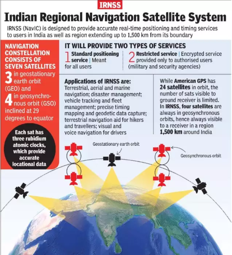
- It consists of a constellation of 7 satellites, which orbit earth in a geostationary or geosynchronous (GEO) orbit, at about 36,000 km from earth. (Refer figure)
- The first of these satellites (IRNSS-1A) were launched in 2013 and the latest in 2018.
- It is designed to provide accurate position information service to users in India as well as the region extending up to 1500 km from its boundary.
- IRNSS provides two types of services:
- Standard Positioning Service (SPS), which is provided to all the users
- Restricted Service (RS), which is an encrypted service provided only to the authorised use.
- NavIC became operational in 2018. However, full-fledged operation was hindered as some of its seven satellites have failed.
- Other navigation systems:
- USA’s Global Positioning System (GPS, originally Navstar GPS)
- Europe’s Galileo
- Russia’s GLONASS
- China’s Beidou
- Japan’s QZSS
PROPOSED UPGRADES:
- Replacement of satellites:
- Five satellites would be launched in the coming months to replace the defunct ones.
- Regional to global changeover:
- ISRO has approached the government for permission to launch an additional 12 satellites in the Medium Earth Orbit (MEO) to expand the reach of NaVIC.
- Improved bands:
- To offer better global positioning services to the public, satellites will be equipped with L1 band besides the current L5 and S bands.
- Enhanced safety:
- Currently, NavIC only provides short code. It is proposed to change it to Long Code for the use of the strategic sector, as it prevents the signal from being breached.
SIGNIFICANCE OF NavIC:
- Strategic autonomy:
- NavIC was developed partly because access to foreign government-controlled global navigation satellite systems is not guaranteed in hostile situations and India wants to reduce its dependence on such systems.
- NAVIC could propel technological innovations and spin-offs that render South Asia progressively less reliant on technological imports from the West and elsewhere.
|
Note:
When Pakistani troops took positions in Kargil in 1999, one of the first things Indian military sought was GPS data for the region. The data would have provided vital information, but the US denied it to India. This made India realise the criticality of an India-owned navigation system.
|
- Strengthen cybersecurity:
- India plans to expand NavIC into the civilian sector, especially onto mobile devices. This reduces the vulnerability of devices to potential espionage.
- Diplomatic tool:
- Sharing the benefits of NavIC strengthens India’s credentials as a collaborative partner in the South Asia region.
- Disaster management:
- NAVIC has instruments useful for environmental and meteorological monitoring. This can be used to design reliable and efficient prediction and response mechanisms to manage natural disasters.
- Agricultural development:
- Through land-area mapping, yield monitoring and precision-planting of crops, NAVIC allows for the development of civic capabilities in food and livelihood security.
- Reduce logistics cost:
- NavIC has higher precision than GPS. This could help with better route optimization and encourage the use of drones for logistics. This can help meet the objectives of the National Logistics Policy.
WAY FORWARD:
- Compatibility:
- NavIC is not in wide use in India primarily because mobile phones have not been made compatible to process its L5 and S band signals. The introduction of L1 band could help overcome this issue.
- Government incentives:
- Government has been aggressively promoting NavIC but smartphone manufacturers want time - at least till 2025. Hence, government must incentivize the manufacturers for faster adoption.
- Extend range:
- Currently, beyond the 1500 km range, equipments using NavIC have to use other systems. To make the system global at some point, India should develop plans to add Middle Earth Orbit satellites to the system.
PRACTICE QUESTION:
Q. Why is Indian Regional Navigational Satellite System (IRNSS) needed? How does it help in navigation? (GS 1, UPSC 2018)