Sir Creek Dispute
2020 MAR 11
Mains >
Security > Border area management > Indo Pak border
IN NEWS:
In the recently concluded WION global summit in Dubai, there were discussions related to the ongoing dispute over Sir Creek between India and Pakistan.
GEOGRAPHY:
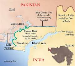
- Sir Creek, originally Ban Ganga, is a 96 km tidal estuary in the Indus river delta on the border of India and Pakistan.
- The creek opens up into the Arabian Sea and separates Gujarat in India from the Sindh province of Pakistan.
- It is a fluctuating tidal channel. The land is marshy, with salty mudflats around it and is largely uninhabited.
THE DISPUTE:
- The Creek became first disputed between the Rao of princely state of Katch and the Chief Commissioner of Sindh Province of British India due to different perceptions of the boundaries. This was solved by signing the Bombay Governmet Resolution of 1914.
- This verdict has two contradictory paragraphs, which is the root to the dispute since independence.
- Paragraph 9 of the verdict states that the boundary lies ‘to the east of the Creek,’ which effectively implied that the creek belonged to Sindh and, therefore, to Pakistan.
- But Paragraph 10 states that the Creek is navigable most of the year. According to international law and the Thalweg principle, a boundary can only be fixed in the middle of the navigable channel, which meant that it has be divided between Sindh and Kutch, and thereby India and Pakistan. UNCLOS supports India’s stand.
- After the 1965 war, an international tribunal was established to solve the dispute. In this resolution, India received 90% of its claim. But the westernmost part was left fluid.
- In 1999, the area witnessed tension when a Pakistani aircraft was shot down by Indian Airforce. Since then, several unsuccessful rounds of talks were held and currently status quo is being held.
SIGNIFICANCE OF THE CREEK:
- Strategic:
- Since there is no border fencing on the marshland, terrorists and smugglers could use it to enter the Indian territory. Since the 26/11 terror attacks, the strategic importance of the creek has increased manifold.
- Also, a demarcation according to the Thalweg principle would result in the gain of an appreciable portion of territory for India.
- Economic:
- Sir Creek is considered to be one of the largest fishing grounds in Asia. Also, the marshlands are estimated to be rich in hydrocarbons and shale gas.
- Once the boundaries are defined, it would help in the determination of the maritime boundaries and thereby the limits of Exclusive Economic Zones (EEZs). EEZs extend to 200 nautical miles (370 km) and can be subjected to commercial exploitation.
- Social:
- Both governments regularly arrest fishermen who cross the borders unwittingly. This unawareness is added with wind flow, waves and turbulence that push the boat in sea. Their release happens only through the land boundary (Wagha border) and hence poor fishermen have no choice but to return home without their boats and equipment.
- Ecological:
- The creek and adjoining areas are important habitat for distinct fauna and flora, such as flamingoes and other migratory birds. The western side of Sir Creek was already declared a Ramsar wetland by Pakistan in 2002. Due to the dispute, it has been unable to take effective conservation measures such as joint management of the area.
ISSUES PREVENTING DISPUTE RESOLUTION:
- Geographical terrain: The region is mostly uninhabited and covered with marsh lands and channels that are difficult to monitor. These ever-shifting creeks, exit Indian territory, enter Pakistan, reenter India and vice versa, thus creating hard to patrol marshy wetland border with no physical barrier or fencing.
- Shifting course: Sir Creek has changed its course considerably over the years. If the boundary line is demarcated according to the Thalweg principle applied to the current channel, Pakistan and India would both lose small amounts of wetlands territory that was historically part of their provinces.
- Trust deficit: If India gives up control of the Creek, there is no guarantee that Pakistan would not claim any new territory in the sector, particularly when some oil or gas resource is discovered.
- Pak’s reluctance to follow Simla Agreement: India maintains that under the bilateral Simla Agreement all bilateral disputes should be resolved without the intervention of third parties. However, Pakistan has proposed that the two sides go in for international arbitration, which India has flatly refused.
CONCLUSION:
- India has taken strategic measures to neutralize the threats it faces along Sir creek. The Border Security Force (BSF) has deployed All-terrain vehicles, speedboats, floating border outposts and Crocodile Commandos specially trained for patrolling such difficult terrains.
- By further expanding the use of modern technologies to laser grids and unmanned aerial vehicles, India can effectively tackle the threats posed by this border.
- However, there must be efforts to tackle the fishermen crisis peacefully. For the same, boats must be mandatorily fixed with GPS navigation systems. Also, visible demarcations should be made in possible areas. Both countries should also find ways to ensure that unaware fishermen are not robbed of their livelihood because of this cartographic dilemma.
- The dispute is not that big a problem as Kashmir but enough to contribute in the strained relationship. However, in the present situations, it might be some time before a consensus is reached.
PRACTICE QUESTION:
Q. The Sir creek dispute stems from history, but economic and strategic significance makes it more relevant today. Examine?