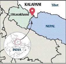
Kalapani
2020 JUN 17
Preliminary >
Geography > Places in news > Places in news
IN NEWS:
- A diplomatic row has broken out between India and Nepal after Nepal passed a bill that included Kalapani, currently under Indian control, in Nepal’s territory.

ABOUT KALAPANI:
- The Kalapani territory is an area under Indian administration as part of Pithoragarh district in the Uttarakhand state.
- According to Nepal's claim, it lies in Darchula district in Nepal.
- The territory represents the basin of the Kalapani river, one of the headwaters of the Kali River in the Himalayas at an altitude of 3600–5200 meters.
- The valley of Kalapani, with the Lipulekh Pass at the top, forms the Indian route to Kailash–Manasarovar, an ancient pilgrimage site.
- It is also the traditional trading route to Tibet for the Bhotiyas of Uttarakhand and Tinkar valley.
BASIS OF DISPUTE:
- According to the Sugauli treaty signed between Nepal and British India in 1816, the Mahakali river that runs through the Kalapani area is the boundary between the two countries.
- However, British surveyors subsequently showed the origin of the river, which has many tributaries, at different places.
- While Nepal claims that the river west of the disputed territory is the main river and so Kalapani falls in its territory, India claims a different origin and includes the area in its territory.
- Strategically, Lipulekh Pass in Kalapani serves as an important vantage point for India to keep an eye on Chinese movements.
PRACTICE QUESTION:
Q. Kalapani region, recently in news, lies in the state of :
- Uttarakhand
- Sikkim
- Bihar
- Uttar Pradesh
Answer to Prelims question
