McMahon Line
2023 MAR 17
Preliminary >
Geography > Places in news > Places in news
Why in news?
- Two United States Senators have introduced a resolution in the upper chamber of Congress reiterating that the US recognises the McMahon Line as the international boundary between China and India in Arunachal Pradesh.
- The resolution reaffirms India’s well-known and established position that Arunachal Pradesh, which China calls ‘South Tibet’, is an integral part of India.
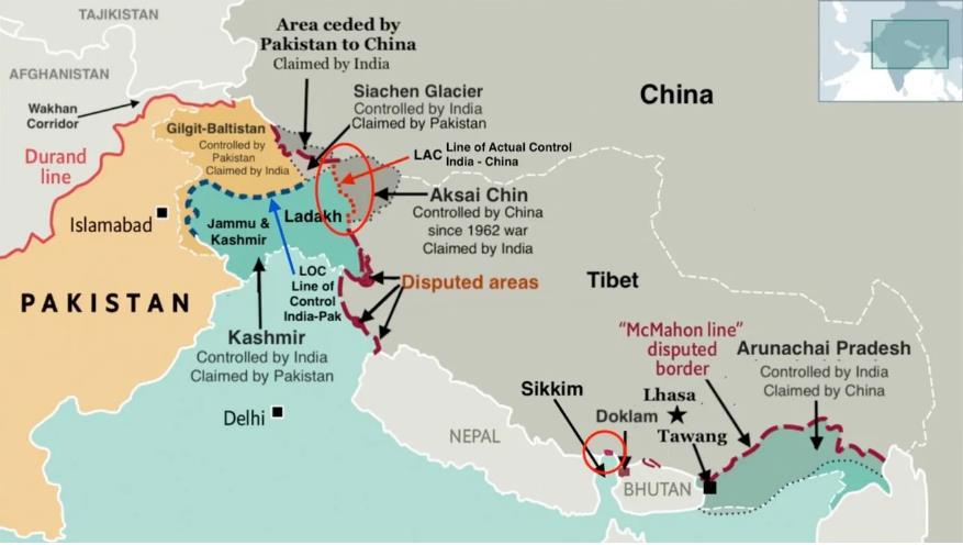
About McMahon Line:
- The McMahon Line serves as the de facto boundary between China and India in the Eastern Sector.
- It specifically represents the boundary between Arunachal Pradesh and Tibet, from Bhutan in the west to Myanmar in the east.
- China has historically disputed the boundary and claims the state of Arunachal Pradesh as part of the Tibetan Autonomous Region (TAR).
???????Background:
- The McMahon Line was drawn during the Simla Convention of 1914, officially described as the Convention between Great Britain, China, and Tibet.
- The convention defines the boundary between Tibet and China proper and that between Tibet and British India (with the latter coming to be known as the McMahon Line).
- There were disputes regarding the McMahon line from the very beginning after the communists took power in 1949. They pulled China out of all international agreements and the so-called “unequal treaties” that had been imposed on it during its “century of humiliation”, and demanded a renegotiation of all its borders.
Add ons:
- During the 1962 Sino-Indian War, China made deep inroads into Indian territory across the McMahon Line. However, its forces retreated to pre-war positions after the unilateral ceasefire was announced.
PRACTICE QUESTION:
‘McMahon Line’, often mentioned in news, is a boundary between India and
(a) Pakistan
(b) Afghanistan
(c) Bangladesh
(d) China
Answer